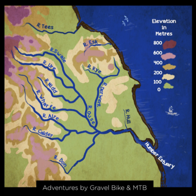
The Source to Sea Trail is an adventure by gravel bike or mountain bike into the heart of Yorkshire on old tracks set in the folds of the hills and on the moors where 10 of Yorkshires finest rivers rise.
This is the only bikepacking trail in the world that traces the watershed - the ridge of high ground - of a single large scale basin where rivers such as the Aire, Calder, Derwent, Esk, Nidd, Swale, Wharf, Ure and Don have their source and follows their flow to the sea.
The trail connects bridleways across the Yorkshire Dales, North York Moors, the northern edge of the Peak District and the South Pennines. The trail is 70% 'off-road' with farmers double track across millstone grit, singletrack across limestone and greenways on canal towpaths and reclaimed railway lines.
It is the only bikepacking trail in the world that traces the watershed - the ridge of high ground - of a single large scale basin where rivers such as the Aire, Calder, Derwent, Esk, Nidd, Swale, Wharf, Ure and Don have their source and follows their flow to the sea.


Above Muker in Swaledale

Farndale Moors in North Yorkshire

Cleveland Hills

Whitby to Scarborough on the Cinder Track on the east coast

Vale of York

Approach to the Humber Bridge